
Park Blvd. Reconfiguration
Poor Planning, Poor Communication, or Both?
As reported in the June 2022 UH News (with additional/updated content)

Rendering of current plan, Park Blvd from Adams to Meade eliminating center/turn lane, adding barricaded cycle track, and removing nearly 40% of parking.
In late March, the City of San Diego resurfaced Park Blvd. from Adams all the way through UH with a new “top coat” or slurry seal. A number of businesses posted on Nextdoor and Facebook about “no parking” tags being posted on their doors for days when work wasn’t being done and how it disrupted their businesses, expressing frustration with the lack of communication from the city.
The following week, when restriping was expected, a news story aired on KPBS (reported by UH resident and KPBS reporter Andrew Bowen) about how Park Blvd. was being reconfigured with bike lanes. The Community Coalition of University Heights (which UHCA is a part of) reached out to Councilmember Whitburn’s office to find out what was going on, as no plans had been shared with the community via public postings or UHCA meetings. The councilmember’s staff responded that they didn’t know about these new city plans either and would investigate.
UHCA President Marc Johnson (who is also a property owner along 4600 Park Blvd.) reached out to the Mayor’s district 3 liaison and the City’s transportation department project manager to find out more details. Over the next several weeks, with little information coming back, more speculation was brewing in the community as business owners were seeing chalk markings being made to the unstriped street that didn’t make sense and as more people were posting on social media about ensuing safety issues, including people not stopping at intersections and near accidents.
The University Heights Parking District, the organization responsible for parking meters and improving parking options, was not approached for input about this plan. Ernie Bonn with the UHCDC board, which provides oversight to the district, said “they are removing parking spaces and haven’t discussed this at all with our City-contracted parking district!”
Carmen Cooley, owner and curator of the J. A. Cooley Museum along 4200 Park Blvd., tenaciously worked through the city’s maze to find someone who could tell her what was going on and received preliminary plans only for her block, which she shared with our organizations. This was the first clue on what was to come.
“When I finally saw the plans that they sent me, I was shocked. Removal of parking, removal of turning lanes, bike lanes with barriers – this looked like 30th Street all over again,” Cooley said. “I begged the Mayor and anyone else to come out here and see how this would impact not just my business, but all businesses on my block, and be a complete nightmare for everyone, but all I heard back was crickets.” Cooley started a petition drive to demand better communication and seeking a dialogue with the city to implement a compromise solution, and at press time has over 1,000 signatures.
As news reports aired on multiple TV stations and public pressure surfaced, representatives from the Mayor’s office and Transportation department stated that they would discuss the plans with the community at the May 5 UHCA Community Meeting. In a preliminary discussion with Johnson, the Mayor’s liaison stated that the bike lanes along Park “have been in the community plans for years, and as we resurface streets, we take advantage of that to implement adding bike lanes where indicated.”

L: Cycle Track Bike Lane - what is being proposed - R: Class II Bike Lane - what is in the community plan
What The Community Plans Show
UH is divided along Park Blvd., with Uptown Planners responsible for west of Park, and North Park Planning Committee responsible for east of Park (with the street divided as well). CCUH member Bill Ellig researched the relevant community plans (Uptown Community Plan November 2019 and North Park Community Plan, 2016) and found proposed bike lanes described as “Class II” along Park Blvd. north of El Cajon Blvd. “Class II lanes are what we have on Cleveland, Maryland, and Madison, separated from the traffic lane. The new plans coming from the city are Cycle Tracks, which people may recognize from 30th Street, a bike lane separated by a buffer zone with physical barriers,” says Ellig.
Johnson also researched both the city and SANDAG plans, and discovered that the “San Diego Bicycle Master Plan, December 2013” also showed a Class II lane, and the SANDAG Regional Bike Plan showed only the Park Boulevard Bikeway starting at Robinson and continuing south.


Uptown Community Plan (left) and North Park Community Plan (right)– both showing Park Boulevard with Class II bicycle lanes. Uptown's plan (page 56) shows the Class II lane changing to Class III at El Cajon Boulevard, and North Park's plan (page 50) shows no bike lane south of El Cajon, with a cycle track configuration starting at Robinson. The complete plans are available online: https://www.uhsd.org/upplan (Uptown) and https://www.uhsd.org/npplan (North Park)
Ahead of the May 5 UHCA meeting, the city publicized their attendance on social media. Bicycle advocacy groups Bike SD and Bike Coalition San Diego County then sent activation emails and social media posts to encourage their members to “attend the virtual meeting and let the city know that you support these cycle tracks!”
UHCA was copied on over a dozen emails from cycling enthusiasts, most of which were copy/paste from a template, including statements encouraging this project due to safety concerns, better access to businesses, and how this project would make the business district more vibrant. Several messages, however, went further, and Johnson engaged with a few of them one to one in order to better understand their perspectives, especially why they felt a Cycle Track was needed on Park Blvd. when there were several alternative Class II bike lanes a few blocks over.
City Reveals Project and Takes Questions

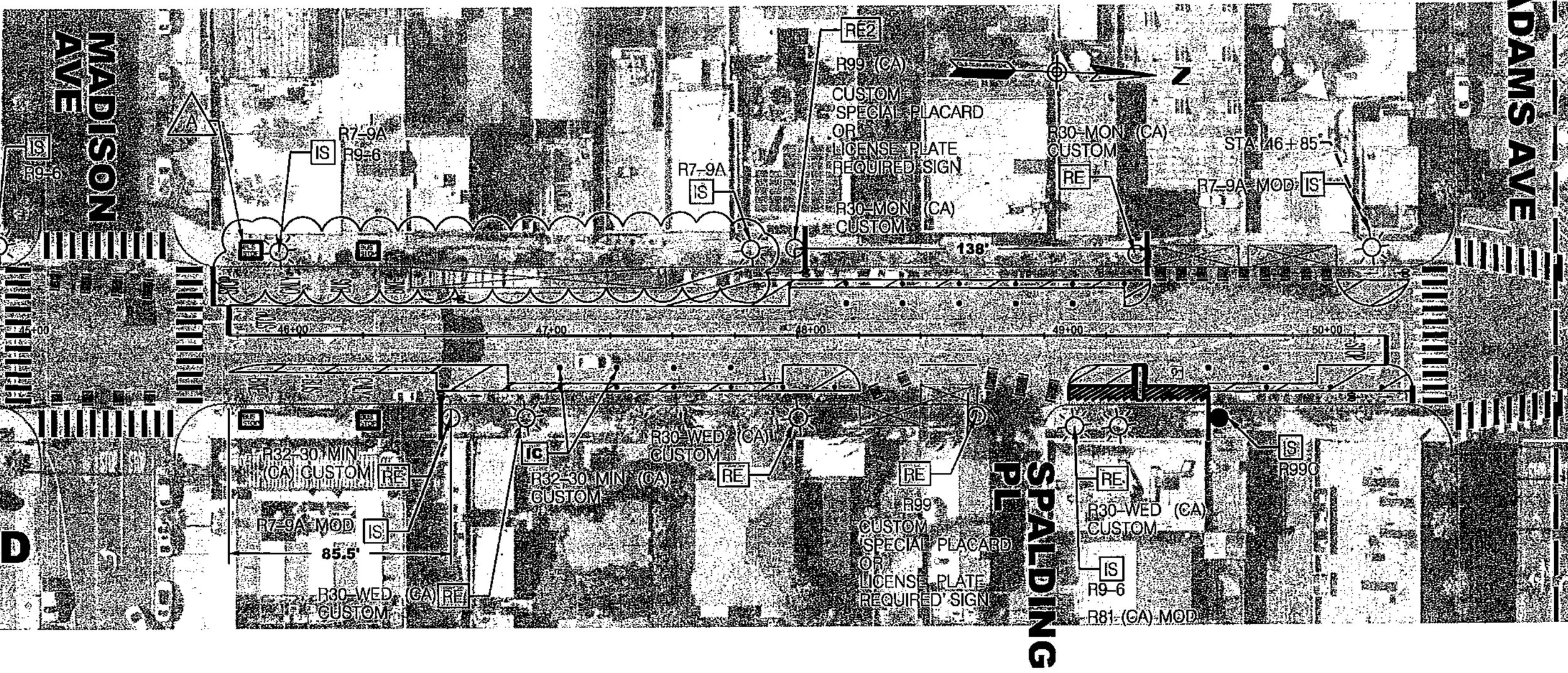
Parking changes on Park Blvd. from Adams to University
At the May 5 meeting, Randy Wilde and Everett Hauser presented the City’s plan and took questions for an hour. They showed how Park Blvd. would be reconfigured to 2 traffic lanes (removing the center/turn lane) with two Cycle Track lanes added from Adams to Meade. At Center Street, shared lanes would be introduced. The reconfiguration would result in changes to parking – a net reduction of 23 spaces from Adams to Monroe in “The Village” business district (-38%), and an overall reduction from Adams to University of 88 parking spaces or 35%. When asked about how this plan doesn’t line up with the community and city plans that did not show Park Blvd. as having a cycle tracks, Hauser stated, “the plans you are referring to are done at the planning level, and they indicate that facilities can changed at the project level.”
Several attendees questioned why the bike lanes were needed on Park Blvd. when wide, less-traveled lanes already exist within a few blocks on Cleveland, Maryland, Georgia, and Florida, with the city representatives responding that the goal is to have bike lanes available to take people directly to their destinations, not out of the way.
Additional questions were raised about how delivery trucks, Uber/Lyft/DoorDash deliveries would work without having the turn/center lane available for drivers to go around (and busses and ambulances to pass), how bicycle parking/storage would work in an area with a high bicycle theft problem already, what safety and traffic data was used to build this plan, and pedestrian safety concerns.
Many of the questions were comments in favor of the project, with attendees expressing the need both for better cyclist safety and how this project will be a positive impact on reducing car emissions. A neighboring North Park resident who lost her husband in a tragic accident along Camino del Rio South last year recounted how protected bike lanes might have prevented her husband’s death.
Several business owners raised concerns about parking, which is already a very difficult proposition in the high-traffic areas, and several residents expressed frustration at how this project was done with little to no communication by the city. Wilde offered apologies for the poor communication, and said that the city was listening to concerns; however, this is the plan that the city will be moving forward with.
As UHCA News goes to press, the striping has not yet begun, and there is no indication that any changes to the new plan are being discussed.
-Community Coalition of University Heights (UHCDC, UHCA, UHHS)
UHCA President’s Corner
Thoughts from Marc Johnson, President of UHCA as published in the June UH News

I normally use this space to talk about how awesome our community is, or about special events coming up. This month, however, I’m going to weigh in on a very hot topic that is happening right now, one that has the potential to dramatically reshape things in UH.
In this issue we have a recap and some viewpoints about the reconfiguration of Park Blvd. I want to address this issue from a few different perspectives: I’m a property owner along Park Blvd. on an HOA board that includes 2 businesses and 4 residences, I’m an enthusiastic cyclist, and I’m an advocate for UH residents and businesses as your UHCA President.
I'm going to be blunt: this street reconfiguration has been an absolute failure of communication and planning from the beginning. The community organizations that have existed for decades were not informed, the parking district that has implemented so many great projects that have increased parking in UH over the years (with more on the books if they get funding) was left completely out of the loop, and even our City Councilmember and his staff were caught by surprise. We only found out about this plan through a news story, and finally (over a month later) from City staff members who finally presented the plan that they were already implenting.
This is not how things should be. We have Community Planning Groups, community associations and other entities who focus on this stuff. We have plans – available online! – that detail what the city should be spending our tax dollars on. These plans have gone through public notification and debate through elected bodies. Yet they are changed without any input, dialogue, or exploration of any compromise – they are enacted by fiat. By unelected city staff members, according to their plans, interpretations, and desires.
As a resident and property owner between Adams and Madison, I can personally attest to how crazy this block can be in the evenings, sometimes with over a dozen ride-share and meal delivery drivers holding on the street. Add to that a lot of pedestrian traffic crossing the street (many times in the middle), plus regular car and bus traffic, and don’t forget this is also an ambulance and fire truck route—and this block sees a lot of near misses. Adding to the safety issues on this block, the street lights that are funded by the UH Maintenance Assessment District (that we pay added taxes for) have been inoperative for over three years, leaving this stretch of Park very dark, but that’s another point of failure that needs to be addressed by the city at another time. During the daytime hours, the center lane is used by USPS, UPS, FedEx, Amazon, and other delivery services. I have not heard yet how those vital services will be accommodated in the city’s plan.
My building has parking for residents, which is great, but businesses don’t. A hair salon is not a place someone is likely to visit on a bike. I don’t know many people who will put a helmet on their freshly styled hair. Neither is a healthcare clinic where many patients are being treated for injuries (and many of them drive with handicap placards on their cars). I also worry about deliveries via our 10-foot alley, which is shared by people living along North and Park. One delivery truck (or garbage truck) can block someone in, and if that is the only place for trucks after Park Blvd. loses the center lane, it will be a problem for dozens of people.
As a cyclist, I avoid Park Blvd. except to cross it. I use Cleveland and Maryland when I need to go south into Hillcrest. I can also use those streets to connect with the Georgia-Meade bikeway to get to Kensington and beyond, and I can also connect to University to get to Mission Hills, and to Balboa Park, Downtown, and beyond via 4th and 5th. Speaking of 4th and 5th, they have wonderful protected bike lanes, until you encounter a large object or person in the lane. Because of the way those streets are laid out, cyclists are “trapped” and can’t swerve out of the way. On 5th especially, a cyclist needs to stop and pick up their bike, get out of the lane to get around the obstacle, and then get back on their way.
I love biking. I love the many trails and bike lanes in our city. I love being able to get from our neighborhood to the waterfront, Mission Bay, PB, Balboa Park, the River – it’s easy and safe. But I can’t use my bike to run errands most of the time. There are very few places where I can lock it up and not worry about it being stolen, and carrying groceries back from Trader Joe’s or Sprouts isn’t practical. I also had an accident last summer because I was not on one of the roads with a dedicated bike lane, and as I moved out of the way of cars, I fell and broke my shoulder (and will be getting surgery on it soon). So I understand the dangers cyclists face and how painful recovery can be. We need safe ways for cyclists to get around. That’s why I’m extra careful about where I bike and the routes I take.
Finally, as your UHCA President, there has to be a compromise that our community and city can reach here. We should be able to find a way to offer cyclists a safe way to get around UH, provide our businesses with precious parking spaces to help ensure their success, and help move more people off of 100% reliance on cars.
As our neighborhood gets more dense, we have to address mobility in a practical, thoughtful, and inclusive way. That means our City – elected and staff – must listen, adapt, explore, and be flexible. They need to observe, gather data, and implement solutions that work for all of us. We as residents and business owners also need to listen, adapt, and be flexible. There is no other way to move forward, but that starts with an open and transparent flow of ideas and consensus building – something I have seen precious little of lately.
Added 5/24: As I’ve been talking with more residents about this, more issues that seem to have been overlooked:
The Winslow University Heights project currently under construction at Park/Meade. This development will have a garage for 500 cars with two egresses - one on Park Blvd. and one along Meade (which will flow onto Park Blvd). How will the volume of cars coming out of this project, especially at peak times, flow? Even without the reconfiguration being proposed, this potential nightmare doesn’t appear to have been factored in.
How does the added congestion that will be caused by losing delivery and turning lanes increase exhaust and contribute to increased CO2 and diesel emissions?
In the detailed plans posted by the city (link here) the traffic count data shows 6,000 cars between Adams and Madison as of 8/2019. Then there is no count until Meade, and then from Meade to Lincoln the data is as of 2/2013 - NEARLY 10 YEARS AGO.
It’s very difficult to see, but in the city plans (link here) the 4600 block of Park Blvd. will be a very confusing, messy situation. Cycle lanes will zig-zag in and out of traffic lanes around outdoor dining, and compete with the bus lane. Turns to and from Madison will be difficult as well. Why can’t the bike lanes be routed around this block to Georgia and rejoin Park at either Madison, Monroe, or Meade?
Voices from our Community
To Whom it May Concern,
I am a cyclist and bike commuter who rides on Park Boulevard on a nearly daily basis. I am writing to voice my opposition to separated cycle tracks on Park Boulevard.
I feel much less safe riding in the "cycle trap" for a couple main reasons. First, bicycles are much less visible to drivers and we are easily ignored when separated from traffic on a side track. On the similar 30th street cycle track, I have had many close calls with cars "right hooking" me by turning across my lane in the cycle track at intersections. In my opinion from years of riding experience, it is safer to ride with traffic using either the sharrows or a class 2 bike lane where I am visible to drivers and won't be hit by turning vehicles that don't see me. This is also the opinion of many of my fellow cyclists and commuters that I have had this conversation with.
Secondly, a separated cycle track creates new hazards that are difficult to avoid. It essentially becomes an extension of the sidewalk, filled by pedestrians and other hazards and debris such as parked electric scooters and trash. For example, pedestrians walking to their Uber cross the 30th Street cycle track without looking, which has also created a lot of close calls for me. Cars also use the cycle track as an additional parking and passenger loading space by pulling into it where there is space. On the 30th street cycle track, parked cars inside the cycle track make it impassable. These hazards cannot be easily avoided because of the bollards trapping the cyclist inside the track. For these reasons, I have actively avoided riding on 30th Street since the installation of similar cycle tracks. If the Park Boulevard cycle tracks are installed, I will also avoid riding on Park Boulevard, or take the full lane with traffic if I must ride there.
From a community relations perspective, I also acknowledge that parking is already difficult in my neighborhood next to Park Boulevard and along Park Boulevard. Cycle tracks would remove too much parking and create more animosity between cyclists, drivers, and local businesses.
— Tom McCarthy
I’m writing to encourage you to support the proposed cycle tracks on Park Boulevard in University Heights. As a resident of San Diego/County/University Heights, I rely on safe bicycle infrastructure to get around the city and access the places I need to go to meet my daily needs.
Currently, I feel unsafe riding on Park Boulevard through University Heights. Without a dedicated bike facility, I am regularly close-passed by drivers and squeezed against the parked cars on the sides of the road, putting me at risk of being hit with the door of someone getting out of their parked car. Because of these unsafe conditions, I am much less likely to ride on this road and visit the local businesses than I otherwise would be.
Building a separated cycletrack on this section of Park Boulevard would not only make me feel safe, but would make me feel more comfortable bringing friends and family who are new to riding bicycles to this area. Moreover, a cycle track would slow traffic down and make this street more comfortable for everyone, whether they choose to bike, walk, drive, or take transit. Although I’ve always loved University Heights, I’ve always believed that the business district could become much more vibrant if it dedicated more space to bikes and pedestrians and people riding bikes, and less to cars.
The Park Boulevard Cycle Tracks will make all road users safer, and will make University Heights into an even more beautiful and vibrant community. I encourage you to support the expedited implementation of this bike facility.
— "Daniel" (sent via anonymous email account, copy/pasted from the SD Bike Coalition email)
The reconfiguration of Park Blvd is a sad example of a city government run amok, not listening to citizens, and implementing changes without communication or transparency.
My family has owned one of the oldest businesses (and a community landmark, Frank the Trainman) for 80 years - 25 years as the non-profit JA Cooley Museum. We were blindsided when we saw people from the transportation department marking the street in front of our building on the 4200 block of Park Blvd. This led to weeks of the City ignoring our calls and refusing to share the details of the new street design, forcing me to reach out to local news media. It was not until they started airing this story that we finally got information on what was being done to our Community.
Once we saw the plan, we reached out to other businesses, property owners and local residents - no one had a clue about the City's plans. After we started posting about this on Nextdoor, Facebook, Instagram, and with the coverage from the news media, we heard from nearly a thousand voters who were frustrated with the City’s lack of communication and transparency.
We brought in a civil engineer who has worked with the City previously and he pointed out numerous flaws with the current plan that will likely cause damage to our property due to the poor drainage infrastructure, have numerous safety issues for pedestrians and motorists alike, and have potential ADA compliance problems which could cost the City if litigation is brought.
In numerous meetings with UH, North Park, and Hillcrest community groups, a common question has been raised: “where are the data, reports, and environmental and business impact studies?”
The City has so far refused to share any of this information, despite it being public. In fact, the current plans do not look at all like what is in the Community Plans for both North Park and Uptown – plans that were adopted by boards that were elected by residents and business owners in this community.
We are not against bike lanes – what we demand is that the City be transparent and look at a compromise that serves cyclists, businesses, and actually helps make our community safer and better. We do not want to see past mistakes like what recently happened in Mira Mesa and Rancho Penasquitos be repeated here. We ask that our City represent the 1,410,000 residents that you are elected to work on behalf of, and not cater to the minority special interest groups and lobbyists that are backing this plan.
— Carmen Cooley Graham, JA Cooley Museum